The current business model for humanitarian crises means that emergency response often only happens when a crisis has already escalated and attracted enough media attention. At this stage many lives have already been lost. The Start Network is working to re-dress the balance, by ensuring that humanitarian funding can be allocated where and when it is needed, regardless of whether it’s in the media headlines.
As Crisis Anticipation Advisor I work at the Start Network with our network members, and a wider group of DFID Rapid Response Facility (RRF) NGOs, to improve their ability to anticipate crises. By investing in better understanding of risk and vulnerability, and systems that can monitor changes in risk and translate this into resourcing requirements, the Network will be better placed to achieve impact with the resources that we have.
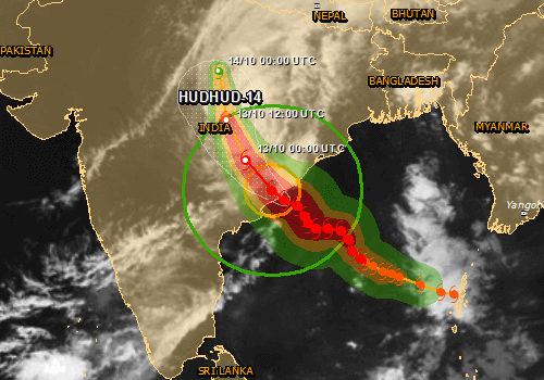
Cyclone Hudhud
A couple of weeks ago I was provided with an opportunity to gather a kind of baseline for the Network’s anticipatory capacity. This came in the form of a Start Fund Allocation Committee meeting made up of twelve Humanitarian Directors who convene to decide where and when to allocate funds. This was called on 10th October in response to the alert for the approaching Cyclone HudHud which was due to make landfall on 12th October.
This was the first time that the committee had met to discuss an ‘anticipatory’ alert, as the crisis had not yet taken place. Only a couple of agencies raised concerns with the principle of allocating funds before an emergency has hit, most were actually comfortable with the idea. Nevertheless, the committee eventually voted against an allocation in advance due to too much uncertainty. This has raised a number of interesting questions for me to follow up on.
India's East Coast is an area which is frequently battered by cyclones, why was there so much uncertainty?
The agencies raised uncertainty around two areas; (i) the impact of the storm (would it strengthen, weaken, blow off course and hit another area?) and (ii) the likely government response and therefore the needs to be covered by NGOs.
Uncertainty is best looked at in contrast to the concept of risk:
Risk – is something that you can put a price on, i.e it can be framed in terms of probability (for example there is an 80% chance that the cyclone will make landfall in location X)
Uncertainty – is risk that is hard to measure. You have an awareness about what might happen, but no way to measure the likelihood of it happening.
(definitions from the Signal and the Noise, Nate Silver)
So whilst our allocation committee can, and frequently does, grapple effectively with concepts of risk, in the face of uncertainty they found themselves unable to make resource allocation decisions.
So the question is, how do we convert uncertainty into risk information?
In the example of Hudhud we had lots of information available to the committee about the likely impact of the storm – particularly via the GDACS (Global Disaster Alert and Coordination System) reports. However none of these predictions were very clearly framed in probabilistic terms. GDACS tells you what time the storm will hit, where and what the impact will be, but appears to give one version of events and does not allow for the possibility of this not happening. It was therefore not enough to help a committee to try to decide whether and how to respond, as they could not evaluate how certain this prediction really was.
However, many other forecasts swing too far the other way. As outlined in this paper on forecast-based humanitarian decisions, climate scientists often report on impending threats through tables or technical statements that are fairly in-comprehensible for us non-specialists. I have many great examples in my inbox, for example a recent one from Impact Forecasting:
"Hurricane Odile has been undergoing a concentric eyewall cycle since the previous NHC advisory, and an Air Force Reserve Reconnaissance Aircraft has found a small inner eye of about 12-mile-diameter and an outer eye of 41-mile-diameter. Despite this normally unfavorable inner-core structure, the central pressure has decreased to 922 millibars, and the maximum flight-level winds have continued to increase in the northeastern quadrant..."
Whilst I’m sure this is scientifically sound, this is very hard for the average humanitarian to use for decision-making!
We seem to be looking for a forecast that lies somewhere in-between the single scenario forecast and the forecasts consisting of descriptions of multiple scientific variables.
We also need to know as much about the data that we are dealing with as possible. For example, weather forecasters are very good nowadays at predicting the location of cyclone landfalls but apparently still weak at predicting its likely intensity. This is the kind of essential information we need to have when appraising a forecast.
Over the next few months I’ll be looking to support the allocations committee to equip them with better forecast information, and a better understanding of this information. The next time we have a similar situation I hope we will be better placed to use climate forecasts to evaluate risks effectively and make timely resource-allocation decisions where appropriate.
Do you have any examples or ideas for using climate forecasts in a humanitarian situation like this? If so please comment below or get in touch by twitter @emilymontier or email e.montier@savethechildren.org.uk